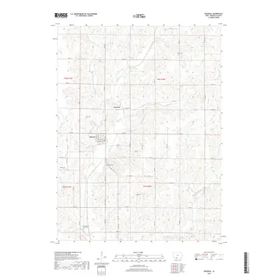
2018 Map of Diagonal
USGS Topo · Published 2018About this map
Diagonal and the neighboring settlement of Knowlton anchor this Ringgold County landscape, where the Grand River and its various tributaries carve a complex drainage pattern through the Iowa countryside. The area is notably dense with small rural burial grounds, including the curiously named Dead Man's Curve Cem and the heritage-rich Bohemian Cem. These sites, along with Quinn Cem, Knowlton Cem, and Bethel Cem, offer significant geographic markers for genealogical research into the families who settled this region of the state.
Find a feature on this map
38 named features on this map. Tap any name to fly to it.
Don’t see what you’re looking for? This feature index may not catch every label — zoom into the map to look around manually.
Map Details
Editions of this 2018 Diagonal Map
This is the sole edition of this map. No revisions or reprints were ever made.
Other maps of this area

1940 · Blockton
USGS Topo · 1:62,500

1943 · Blockton
USGS Topo · 1:62,500

1945 · Mount Ayr
USGS Topo · 1:62,500

1947 · Mount Ayr
USGS Topo · 1:62,500

1955 · Nebraska City
USGS Topo · 1:250,000

1957 · Nebraska City
USGS Topo · 1:250,000

1958 · Nebraska City
USGS Topo · 1:250,000
1981 · Arispe
USGS Topo · 1:24,000
1981 · Shannon City
USGS Topo · 1:24,000
1981 · Diagonal
USGS Topo · 1:24,000