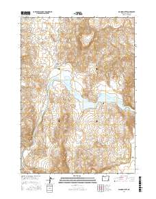
2017 Map of Diamond Butte
USGS Topo · Published 2017About this map
Lake Owyhee dominates the central landscape of this Malheur County survey, where the Owyhee River enters the reservoir. The topography is defined by high volcanic landmarks, most notably Diamond Butte and Red Butte, which rise above a network of drainages including Red Butte Canyon and Blue Canyon. The presence of the Watson Cem near the water's edge provides a rare point of genealogical interest in this sparsely populated region, marking a site connected to the historical settlement of Watson. Water sources are vital in this high desert terrain, as evidenced by several mapped points like Hot Spring, Red Rock Spring, and Gillespie Spring. The southern reaches of the map show the seasonal catchment of Tule Lake beneath the prominent ridge of The Tongue. Access is limited to the single Owyhee Rd, emphasizing the isolation of this corner of eastern Oregon.
Find a feature on this map
20 named features on this map. Tap any name to fly to it.
Don’t see what you’re looking for? This feature index may not catch every label — zoom into the map to look around manually.
Map Details
Editions of this 2017 Diamond Butte Map
This is the sole edition of this map. No revisions or reprints were ever made.
Other maps of this area

1955 · Boise
USGS Topo · 1:250,000

1958 · Boise
USGS Topo · 1:250,000

1962 · Boise
USGS Topo · 1:250,000

1967 · Pelican Point
USGS Topo · 1:24,000

1967 · Diamond Butte
USGS Topo · 1:24,000

1967 · Rooster Comb
USGS Topo · 1:24,000

1967 · Quartz Mtn Basin
USGS Topo · 1:24,000

1969 · Mc Cain Creek
USGS Topo · 1:24,000

1969 · Jordan Craters North
USGS Topo · 1:24,000

1972 · Big Mud Flat
USGS Topo · 1:24,000