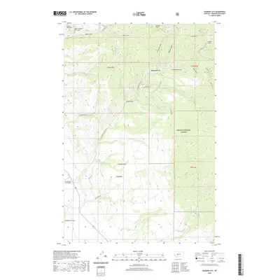
2020 Map of Diamond City
USGS Topo · Published 2020About this map
Diamond City and the historic gold-mining district of Confederate Gulch define this mountainous landscape within the Helena National Forest. The map documents a rugged terrain carved by numerous drainages, including White Gulch, Miller Gulch, and Greenhorn Gulch, which were the sites of significant placer mining activity in the late 19th century. Near the center of the sheet, the Diamond City Cem serves as a silent reminder of the boomtown era that once thrived here. To the west, the Elk Meadows Ranch Airport provides modern access to these remote highlands. The drainage patterns of Spruce Cr, Hinaman Cr, and Clear Cr illustrate the complex watershed that flows from the Boulder Lakes area, tracing a path through the steep gulches that once drew thousands of prospectors to this corner of Broadwater County.
Find a feature on this map
37 named features on this map. Tap any name to fly to it.
Don’t see what you’re looking for? This feature index may not catch every label — zoom into the map to look around manually.
Map Details
Editions of this 2020 Diamond City Map
This is the sole edition of this map. No revisions or reprints were ever made.
Other maps of this area

1886 · Fort Logan
USGS Topo · 1:250,000

1948 · White Sulphur Springs
USGS Topo · 1:250,000

1950 · Canyon Ferry
USGS Topo · 1:62,500

1950 · Townsend
USGS Topo · 1:62,500

1950 · Duck Creek Pass
USGS Topo · 1:62,500

1958 · White Sulphur Springs
USGS Topo · 1:250,000

1961 · White Sulphur Springs
USGS Topo · 1:250,000

1965 · White Sulphur Springs
USGS Topo · 1:250,000

1966 · Boulder Baldy
USGS Topo · 1:24,000

1966 · Diamond City
USGS Topo · 1:24,000