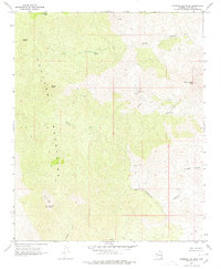
1967 Map of Diamond Joe Peak
USGS Topo · Published 1978About this map
The Hualapai Mountains dominate this high-altitude landscape in the late 1960s, defined by a series of prominent summits including Pine Peak, Burch Peak, and the namesake Diamond Joe Peak. The terrain is marked by deep drainage systems such as Crow Canyon and Deluge Wash, where water sources like Grapevine Spring and Chappo Spring provided critical resources in this arid environment. Human activity is evidenced by the industrial presence of the Leviathan Mine and scattered Prospects, alongside unnamed Ruins found near the junction of Cedar and Tompkins Canyon. Movement through this steep country relied on a network of a Jeep Trail and a Foot Trail, illustrating the remote and difficult nature of the region before modern infrastructure. This 1967 survey offers a detailed look at the transition from mining operations to backcountry wilderness in the Arizona interior.
Find a feature on this map
20 named features on this map. Tap any name to fly to it.
Don’t see what you’re looking for? This feature index may not catch every label — zoom into the map to look around manually.
Map Details
Editions of this 1967 Diamond Joe Peak Map
2 editions found
Other maps of this area

1923 · Signal
USGS Topo · 1:250,000

1942 · Signal
USGS Topo · 1:250,000

1950 · Prescott
USGS Topo · 1:250,000

1954 · Prescott
USGS Topo · 1:250,000

1958 · Prescott
USGS Topo · 1:250,000

1959 · Prescott
USGS Topo · 1:250,000

1960 · Prescott
USGS Topo · 1:250,000

1965 · Prescott
USGS Topo · 1:250,000
1967 · Gunsight Canyon
USGS Topo · 1:24,000
1967 · Beecher Canyon
USGS Topo · 1:24,000