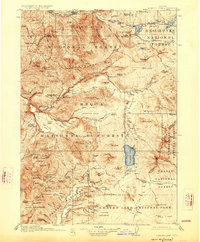
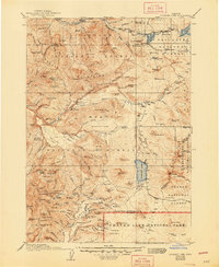
1917 Map of Diamond Lake
USGS Topo · Published 1926About this map
Diamond Lake sits at the heart of this high-elevation landscape, where the headwaters of the North Umpqua River and the Middle Fork Willamette River diverge toward their respective valleys. Surveyed just before the First World War, the map captures a wilderness transitioning into a managed resource under the emerging oversight of the Deschutes National Forest, Umpqua National Forest, and Crater National Forest. Communication and logistics in this era relied on isolated outposts such as the Rigdon Ranger Sta and the Mountain Meadows Ranger Station. Historical transportation corridors including the Military Road and the Ft Klamath Road represent early efforts to traverse the High Cascades. From the dramatic precipice of Mt Thielsen to the tumbling Lemolo Falls, the topography reflects a land defined by volcanic geology and the early development of Crater Lake National Park at its southern edge.
Find a feature on this map
169 named features on this map. Tap any name to fly to it.
Don’t see what you’re looking for? This feature index may not catch every label — zoom into the map to look around manually.
Map Details
Editions of this 1917 Diamond Lake Map
3 editions found
Other maps of this area

1889 · Klamath
USGS Topo · 1:250,000

1891 · Ashland
USGS Topo · 1:250,000

1893 · Ashland
USGS Topo · 1:250,000

1894 · Klamath
USGS Topo · 1:250,000

1897 · Ashland
USGS Topo · 1:250,000

1917 · Diamond Lake
USGS Topo · 1:125,000

1925 · Waldo Lake
USGS Topo · 1:125,000

1930 · Maiden Peak
USGS Topo · 1:125,000

1934 · Maiden Peak
USGS Topo · 1:125,000

1935 · Lowell
USGS Topo · 1:96,000