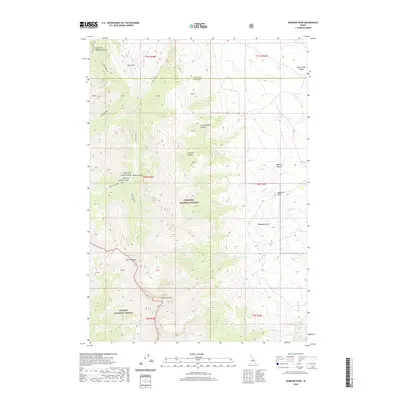
2020 Map of Diamond Peak
USGS Topo · Published 2020About this map
Diamond Peak dominates the southern skyline of this high-elevation landscape where the Lemhi Range meets the border of Butte and Lemhi counties. The map captures a transition between the Targhee National Forest and Challis National Forest, defined by a network of steep canyons and drainages. Topographic patterns reveal the stark descent from the mountain crest into Birch Creek Valley to the northeast. High-country drainage systems are meticulously charted, including the South Fork Meadow Canyon and the Right Fork Rocky Canyon, while lower elevations feature named draws like Kaufman Gulch and Shamrock Gulch. This modern survey provides essential geographic data for understanding the hydrologic connections of N Fork Pass Cr and the complex timber and grazing lands of the interior Rockies.
Find a feature on this map
25 named features on this map. Tap any name to fly to it.
Don’t see what you’re looking for? This feature index may not catch every label — zoom into the map to look around manually.
Map Details
Editions of this 2020 Diamond Peak Map
This is the sole edition of this map. No revisions or reprints were ever made.
Other maps of this area

1955 · Dubois
USGS Topo · 1:250,000

1956 · Nicholia
USGS Topo · 1:62,500

1957 · Diamond Peak
USGS Topo · 1:62,500

1957 · Scott Peak
USGS Topo · 1:62,500

1958 · Dubois
USGS Topo · 1:250,000

1969 · Eightmile Canyon
USGS Topo · 1:24,000
1969 · Blue Dome
USGS Topo · 1:24,000

1983 · Dubois
USGS Topo · 1:100,000
1987 · Fallert Springs
USGS Topo · 1:24,000
1987 · Nicholia
USGS Topo · 1:24,000