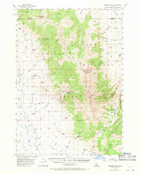
1957 Map of Diamond Peak
USGS Topo · Published 1971About this map
Diamond Peak dominates the landscape of the Lemhi Range, where the high-altitude divide separates the drainages of the Challis National Forest and the Salmon National Forest. The map documents a mid-century period of mineral exploration and high-mountain ranching in the Little Lost River valley. A small settlement at Clyde serves as a hub for the scattered mining operations like the Valley View Mine and various prospects found along the steep gulches.
Find a feature on this map
58 named features on this map. Tap any name to fly to it.
Don’t see what you’re looking for? This feature index may not catch every label — zoom into the map to look around manually.
Map Details
Editions of this 1957 Diamond Peak Map
3 editions found
Other maps of this area

1955 · Dubois
USGS Topo · 1:250,000

1955 · Idaho Falls
USGS Topo · 1:250,000

1956 · Nicholia
USGS Topo · 1:62,500

1957 · Diamond Peak
USGS Topo · 1:62,500

1957 · Gilmore
USGS Topo · 1:62,500

1957 · Scott Peak
USGS Topo · 1:62,500

1957 · Hawley Mountain
USGS Topo · 1:62,500

1958 · Dubois
USGS Topo · 1:250,000

1958 · Idaho Falls
USGS Topo · 1:250,000

1969 · Eightmile Canyon
USGS Topo · 1:24,000