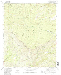
1973 Map of Diamond Point
USGS Topo · Published 1983About this map
Diamond Rim dominates the central landscape of this Gila County survey, where the high elevations of the Tonto National Forest meet a complex network of draws and canyons. The topographical detail reveals a rugged territory marked by landmarks such as Roberts Mesa and Turkey Ridge. Human activity is concentrated around scattered homesteads and infrastructure, including the Pyle Ranch in the north and Tonto Village to the east.
Find a feature on this map
57 named features on this map. Tap any name to fly to it.
Don’t see what you’re looking for? This feature index may not catch every label — zoom into the map to look around manually.
Map Details
Editions of this 1973 Diamond Point Map
2 editions found
Other maps of this area

1887 · Verde
USGS Topo · 1:250,000

1892 · Verde
USGS Topo · 1:250,000

1934 · Pine
USGS Topo · 1:62,500

1934 · Promontory Butte
USGS Topo · 1:62,500

1936 · Payson
USGS Topo · 1:48,000

1937 · Diamond Butte
USGS Topo · 1:48,000

1939 · Promontory Butte
USGS Topo · 1:62,500

1940 · Pine
USGS Topo · 1:62,500

1942 · Payson
USGS Topo · 1:62,500

1943 · Diamond Butte
USGS Topo · 1:62,500
Featured Places
- Star Valley, AZ
- Diamond Point Summer Homes, AZ
- Ellison Creek Summer Homes, AZ
- Little Green Valley, AZ
- Ellison Creek Estates, AZ