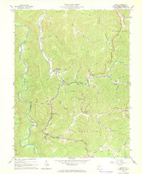
1967 Map of Diana
USGS Topo · Published 1968About this map
Diana and the Right Fork Holly River anchor this mid-century survey of the West Virginia highlands. The terrain is defined by the massive shoulders of Hodam Mountain and Holly Mountain, where small mountain settlements like Jumbo and Kovan are connected by a network of creeks and runs. The presence of numerous rural congregations, including Bethany Ch and Mt Zion Ch, along with the Clifton Ford Cem, provides a detailed look at the social geography of Webster County before late-century consolidation.
Find a feature on this map
64 named features on this map. Tap any name to fly to it.
Don’t see what you’re looking for? This feature index may not catch every label — zoom into the map to look around manually.
Map Details
Editions of this 1967 Diana Map
3 editions found
Other maps of this area

1889 · Nicholas
USGS Topo · 1:125,000

1891 · Nicholas
USGS Topo · 1:125,000

1891 · Huntersville
USGS Topo · 1:125,000

1893 · Buckhannon
USGS Topo · 1:125,000

1893 · Sutton
USGS Topo · 1:125,000

1894 · Huntersville
USGS Topo · 1:125,000

1896 · Buckhannon
USGS Topo · 1:125,000

1897 · Buckhannon
USGS Topo · 1:125,000

1901 · Nicholas
USGS Topo · 1:125,000

1908 · Sutton
USGS Topo · 1:48,000