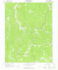
1967 Map of Diana
USGS Topo · Published 1977About this map
Diana serves as a focal point in this West Virginia survey, situated at the confluence of several mountain runs and the Right Fork Holly River. The settlement pattern follows the narrow valley floors, with community life anchored by Bethany Ch and the Holly River Ch. Steep ridges like Elk Mountain and Glade Mountain separate the river systems, creating a landscape where travel was historically dictated by the winding watercourses. Along the Elk River to the west, landmarks such as Clifton Ford and the Gaging Sta reflect the river's importance for local transit and monitoring.
Find a feature on this map
62 named features on this map. Tap any name to fly to it.
Don’t see what you’re looking for? This feature index may not catch every label — zoom into the map to look around manually.
Map Details
Editions of this 1967 Diana Map
3 editions found
Other maps of this area

1889 · Nicholas
USGS Topo · 1:125,000

1891 · Nicholas
USGS Topo · 1:125,000

1891 · Huntersville
USGS Topo · 1:125,000

1893 · Buckhannon
USGS Topo · 1:125,000

1893 · Sutton
USGS Topo · 1:125,000

1894 · Huntersville
USGS Topo · 1:125,000

1896 · Buckhannon
USGS Topo · 1:125,000

1897 · Buckhannon
USGS Topo · 1:125,000

1901 · Nicholas
USGS Topo · 1:125,000

1908 · Sutton
USGS Topo · 1:48,000