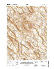
2014 Map of Diatomite Reservoir
USGS Topo · Published 2014About this map
The high desert landscape of Lake County is defined here by a network of essential water sources and specialized industrial activity. The Diatomite Mine stands as a primary feature, marking the extraction of silica-rich sedimentary rock from the terrain near Saunders Rim and Diatomite Reservoir. This 2014 survey documents a region where survival and industry are dictated by water management, evidenced by the numerous named catchments distributed across the townships, including Sammys Horse Pen Waterhole and the Brattain Waterhole Number 4. Access to this remote interior is facilitated by dirt routes like Sheep Rock Rd and Burma Rd, which navigate the elevation changes between the prominent Twin Buttes and the surrounding sagebrush plains.
Find a feature on this map
17 named features on this map. Tap any name to fly to it.
Don’t see what you’re looking for? This feature index may not catch every label — zoom into the map to look around manually.
Map Details
Editions of this 2014 Diatomite Reservoir Map
This is the sole edition of this map. No revisions or reprints were ever made.
Other maps of this area

1955 · Crescent
USGS Topo · 1:250,000

1955 · Klamath Falls
USGS Topo · 1:250,000

1957 · Crescent
USGS Topo · 1:250,000

1958 · Crescent
USGS Topo · 1:250,000

1958 · Klamath Falls
USGS Topo · 1:250,000

1970 · Crescent
USGS Topo · 1:250,000

1974 · Lake Abert
USGS Topo · 1:100,000
1984 · Sawed Horn
USGS Topo · 1:24,000
1984 · Poverty Basin South
USGS Topo · 1:24,000
1984 · Poverty Basin North
USGS Topo · 1:24,000