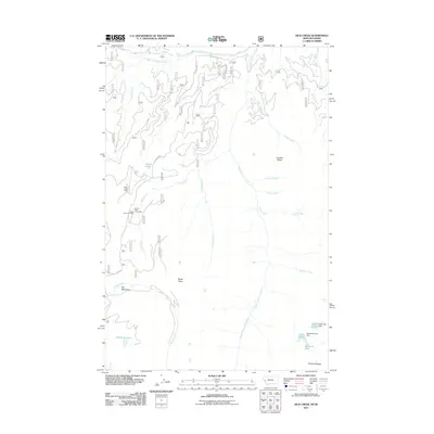
2011 Map of Dick Creek
USGS Topo · Published 2011About this map
Ward Lode Mine and a series of extraction sites including the Upper Dick Creek Mine and Lower Dick Creek Mine define the industrial history of this high-elevation terrain in Missoula County. The 2011 survey reveals a landscape where mining operations were deeply integrated with the drainages of Dick Creek and Johny Creek. The geography is characterized by several distinct water bodies such as Skookum Lake, Marys Pond, and Duffy Lake, which are situated among significant landforms like Lantern Ridge and Pyramid Buttes.
Find a feature on this map
27 named features on this map. Tap any name to fly to it.
Don’t see what you’re looking for? This feature index may not catch every label — zoom into the map to look around manually.
Map Details
Editions of this 2011 Dick Creek Map
This is the sole edition of this map. No revisions or reprints were ever made.
Other maps of this area

1912 · Missoula
USGS Topo · 1:125,000

1956 · Hamilton
USGS Topo · 1:250,000

1959 · Hamilton
USGS Topo · 1:250,000

1960 · Hamilton
USGS Topo · 1:250,000

1964 · Hamilton
USGS Topo · 1:250,000

1964 · Garden Point
USGS Topo · 1:24,000

1964 · Dick Creek
USGS Topo · 1:24,000

1964 · West Fork Butte
USGS Topo · 1:24,000
1964 · Blue Mountain
USGS Topo · 1:24,000
1964 · Camp Creek
USGS Topo · 1:24,000