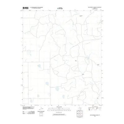
2010 Map of Dick Moore Canyon
USGS Topo · Published 2010About this map
Dick Moore Canyon and the surrounding ranchlands of Motley County are defined by a network of seasonal drainages and local water sources that support the region's agricultural life. The North Pease River meanders through the northern section of the terrain, joined by smaller tributaries such as Tom Handle Creek and Boggy Creek. A series of isolated landmarks, including Boggy Windmill, Chimney Windmill, and Waybourn Windmill, illustrate the ongoing importance of groundwater management in this semi-arid environment. In the southeast, Mott Camp and Mott Creek serve as rare named sites of human activity amidst the expansive cattle country. The landscape is interconnected by a sparse grid of rural routes like FM 28 and various county roads, reflecting the large-scale landholdings and low population density characteristic of the Texas Panhandle fringe during the early 21st century.
Find a feature on this map
19 named features on this map. Tap any name to fly to it.
Don’t see what you’re looking for? This feature index may not catch every label — zoom into the map to look around manually.
Map Details
Editions of this 2010 Dick Moore Canyon Map
This is the sole edition of this map. No revisions or reprints were ever made.
Other maps of this area

1954 · Lubbock
USGS Topo · 1:250,000

1954 · Plainview
USGS Topo · 1:250,000

1958 · Plainview
USGS Topo · 1:250,000

1965 · Boothe
USGS Topo · 1:24,000

1966 · Lockney 4 SW
USGS Topo · 1:24,000

1967 · Quitaque Peaks
USGS Topo · 1:24,000

1967 · Dick Moore Canyon
USGS Topo · 1:24,000

1967 · Flomot
USGS Topo · 1:24,000
1967 · Wilson Creek
USGS Topo · 1:24,000

1967 · Whiteflat
USGS Topo · 1:24,000