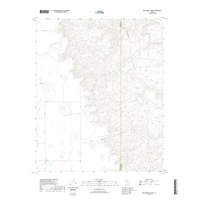
2019 Map of Dick Moore Canyon
USGS Topo · Published 2019About this map
Dick Moore Canyon and the surrounding drainage basins of the N Pease River define this section of West Texas near the border of Floyd and Motley counties. The landscape is marked by a complex network of ephemeral waterways including Boggy Creek, Chimney Creek, and Tom Handle Cr. Water sources such as Miller Springs and Mott Camp Springs served as vital landmarks in this arid ranching country, where roads like FM 28 and various county routes provide the primary access to large land tracts. The 2019 survey illustrates the persistent rural character of the region, showing how the local topography dictates the winding paths of roads like Co RD 112 as they navigate the breaks of the Pease River valley.
Find a feature on this map
22 named features on this map. Tap any name to fly to it.
Don’t see what you’re looking for? This feature index may not catch every label — zoom into the map to look around manually.
Map Details
Editions of this 2019 Dick Moore Canyon Map
This is the sole edition of this map. No revisions or reprints were ever made.
Other maps of this area

1954 · Lubbock
USGS Topo · 1:250,000

1954 · Plainview
USGS Topo · 1:250,000

1958 · Plainview
USGS Topo · 1:250,000

1965 · Boothe
USGS Topo · 1:24,000

1966 · Lockney 4 SW
USGS Topo · 1:24,000

1967 · Quitaque Peaks
USGS Topo · 1:24,000

1967 · Dick Moore Canyon
USGS Topo · 1:24,000

1967 · Flomot
USGS Topo · 1:24,000
1967 · Wilson Creek
USGS Topo · 1:24,000

1967 · Whiteflat
USGS Topo · 1:24,000