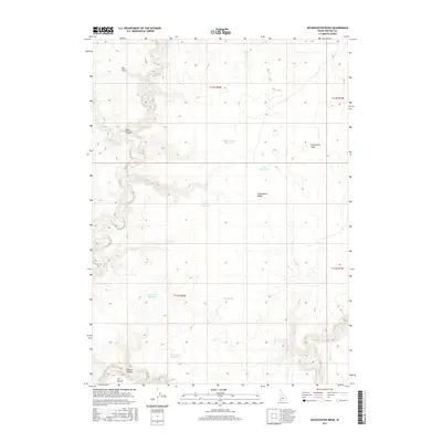
2017 Map of Dickshooter Ridge
USGS Topo · Published 2017About this map
Dickshooter Ridge rises as a central feature of this high-plateau landscape in southern Owyhee County, characterized by a complex network of seasonal water catchments and deep drainage canyons. The southwestern corner is dominated by the Owyhee River as it cuts through the Owyhee Canyon, bordering the arid expanse of the Y P Desert. This region represents a highly managed rangeland environment, where numerous artificial water sources like Dead Tree Reservoir, Kincaid Reservoir, and Jus Reservoir have been established to support livestock in an otherwise dry terrain. Smaller drainages including Dickshooter Cr and Deep Creek carve into the basaltic landscape, feeding into larger systems or terminating in draws like Freshwater Draw. The map illustrates the specialized infrastructure of the Great Basin's edge, where every named spring and catchment is essential to the navigation and utility of the land.
Find a feature on this map
20 named features on this map. Tap any name to fly to it.
Don’t see what you’re looking for? This feature index may not catch every label — zoom into the map to look around manually.
Map Details
Editions of this 2017 Dickshooter Ridge Map
This is the sole edition of this map. No revisions or reprints were ever made.
Other maps of this area

1955 · Jordan Valley
USGS Topo · 1:250,000

1957 · Jordan Valley
USGS Topo · 1:250,000

1958 · Jordan Valley
USGS Topo · 1:250,000
1971 · Jarvis Pasture
USGS Topo · 1:24,000
1972 · Frying Pan Basin
USGS Topo · 1:24,000
1972 · Battle Creek Lakes
USGS Topo · 1:24,000
1973 · Piute Basin West
USGS Topo · 1:24,000

1973 · Castro Table
USGS Topo · 1:24,000
1973 · Dickshooter Reservoir
USGS Topo · 1:24,000

1973 · Brace Flat
USGS Topo · 1:24,000