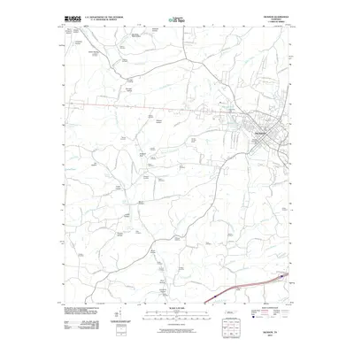
2010 Map of Dickson
USGS Topo · Published 2010About this map
Dickson stands as the primary hub on this map, showing the city's modern layout and its proximity to historical industrial and residential sites. The landscape is characterized by a dense network of cemeteries, such as Union Cemetery and Sullivan Cemetery, which offer significant value for genealogical research. The presence of the Worley Furnace Mines and Worley Furnace Branch points to the area's history of iron production and resource extraction.
Find a feature on this map
121 named features on this map. Tap any name to fly to it.
Don’t see what you’re looking for? This feature index may not catch every label — zoom into the map to look around manually.
Map Details
Editions of this 2010 Dickson Map
This is the sole edition of this map. No revisions or reprints were ever made.
Other maps of this area

1901 · Colombia
USGS Topo · 1:125,000

1936 · Ruskin
USGS Topo · 1:24,000

1936 · Texas Hollow
USGS Topo · 1:24,000

1936 · Spot
USGS Topo · 1:24,000

1936 · Burns
USGS Topo · 1:24,000

1936 · Lyles
USGS Topo · 1:24,000

1936 · Tennessee City
USGS Topo · 1:24,000

1936 · Dickson
USGS Topo · 1:24,000
1952 · Spot
USGS Topo · 1:24,000
1952 · Texas Hollow
USGS Topo · 1:24,000