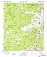
1946 Map of Dillard
USGS Topo · Published 1977About this map
Dillard and Mountain City serve as the primary hubs in this mountainous corridor near the North Carolina border, where the Tallulah Falls RR follows the narrow valley of the Little Tennessee River. The landscape is defined by the high peaks of the Chattahoochee National Forest and Nantahala National Forest, showing a network of rural life tied to the terrain. Higher elevations reveal old industry and agriculture, such as the Queen Mine near Queen Mine Gap and historic milling operations like Kilby Mill and Dickerson Mill. Local community centers are anchored by landmarks like the Rabun Gap Nacoochee Sch and numerous country churches, including Taylor Chapel and Wesley Chapel Cem. The map provides a detailed view of the era's land use, from the recreational grounds of Camp Dixie to the conserved slopes of Blackrock Mountain State Park.
Find a feature on this map
137 named features on this map. Tap any name to fly to it.
Don’t see what you’re looking for? This feature index may not catch every label — zoom into the map to look around manually.
Map Details
Editions of this 1946 Dillard Map
4 editions found
Other maps of this area

1886 · Dahlonega
USGS Topo · 1:125,000

1886 · Walhalla
USGS Topo · 1:125,000

1891 · Cowee
USGS Topo · 1:125,000

1892 · Dahlonega
USGS Topo · 1:125,000

1892 · Walhalla
USGS Topo · 1:125,000

1896 · Walhalla
USGS Topo · 1:125,000

1896 · Dahlonega
USGS Topo · 1:125,000

1897 · Cowee
USGS Topo · 1:125,000

1903 · Dahlonega
USGS Topo · 1:125,000

1907 · Cowee
USGS Topo · 1:125,000