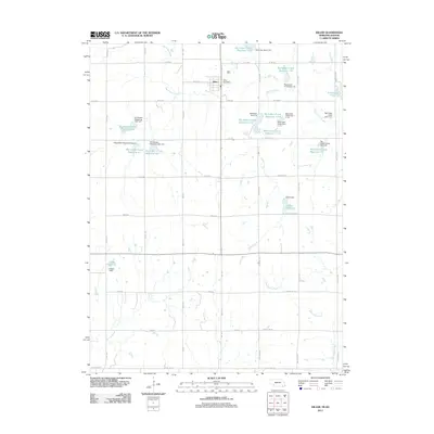
2011 Map of Diller
USGS Topo · Published 2011About this map
The village of Diller serves as the central hub of this agricultural landscape in southern Nebraska, situated just north of State Line Rd. This survey documents a complex watershed management system dominated by the Big Indian Creek and its many tributaries, such as Spring Creek and Horseshoe Creek. The terrain is defined by an extensive network of water control structures, including the Big Indian Creek Reservoir 17-A and several floodwater retarding dams. These features suggest a landscape heavily engineered to support the surrounding farmland against the variability of the plains' water cycles. Beyond the municipal center at the Diller Post Office, the map reveals private water bodies like Callan Reservoir, Clapp Reservoir, and Arrowhead Lake, which highlight the importance of water storage for local rural life and land use.
Find a feature on this map
53 named features on this map. Tap any name to fly to it.
Don’t see what you’re looking for? This feature index may not catch every label — zoom into the map to look around manually.
Map Details
Editions of this 2011 Diller Map
This is the sole edition of this map. No revisions or reprints were ever made.
Other maps of this area

1889 · Marysville
USGS Topo · 1:125,000

1893 · Washington
USGS Topo · 1:125,000

1894 · Marysville
USGS Topo · 1:125,000

1955 · Manhattan
USGS Topo · 1:250,000

1955 · Lincoln
USGS Topo · 1:250,000

1956 · Manhattan
USGS Topo · 1:250,000

1957 · Manhattan
USGS Topo · 1:250,000

1957 · Lincoln
USGS Topo · 1:250,000

1958 · Lincoln
USGS Topo · 1:250,000
1966 · Washington NE
USGS Topo · 1:24,000