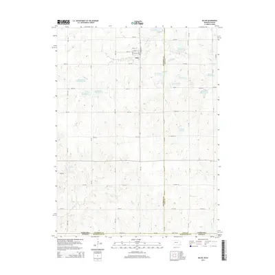
2014 Map of Diller
USGS Topo · Published 2014About this map
The village of Diller serves as the central hub of this agricultural landscape along the Jefferson and Gage County line. The 2014 survey reveals an intricate network of water management features, most notably the extensive series of basins comprising the Big Indian Creek watershed. These include Big Indian Creek Reservoir, Arrowhead Lake, and numerous numbered catchments such as Big Indian Creek Reservoir 7-B and Big Indian Creek Reservoir 17-A.
Find a feature on this map
48 named features on this map. Tap any name to fly to it.
Don’t see what you’re looking for? This feature index may not catch every label — zoom into the map to look around manually.
Map Details
Editions of this 2014 Diller Map
This is the sole edition of this map. No revisions or reprints were ever made.
Other maps of this area

1889 · Marysville
USGS Topo · 1:125,000

1893 · Washington
USGS Topo · 1:125,000

1894 · Marysville
USGS Topo · 1:125,000

1955 · Manhattan
USGS Topo · 1:250,000

1955 · Lincoln
USGS Topo · 1:250,000

1956 · Manhattan
USGS Topo · 1:250,000

1957 · Manhattan
USGS Topo · 1:250,000

1957 · Lincoln
USGS Topo · 1:250,000

1958 · Lincoln
USGS Topo · 1:250,000
1966 · Washington NE
USGS Topo · 1:24,000