
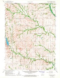
1970 Map of Diller
USGS Topo · Published 1972About this map
Diller serves as the focal point of this 1970s landscape, situated along the Burlington Northern railroad line. The map captures the agricultural and community structure of the borderlands between Jefferson County, Nebraska, and Washington County, Kansas. The terrain is defined by the winding paths of Indian Creek and Big Indian Creek, which carve through the plains near the Kansas Nebraska state line. Rural life is anchored by local landmarks such as the Evangelical Ch and the Pleasant View Sch, reflecting the established network of schools and churches that served the surrounding farmsteads. Industrial footprints are minimal but present, including a Sandpit and several pipelines traversing the southern townships. To the southeast, the small settlement of Lanham sits directly on the state boundary, illustrating the cross-border connectivity of the era.
Find a feature on this map
25 named features on this map. Tap any name to fly to it.
Don’t see what you’re looking for? This feature index may not catch every label — zoom into the map to look around manually.
Map Details
Editions of this 1970 Diller Map
This is the sole edition of this map. No revisions or reprints were ever made.
Other maps of this area

1889 · Marysville
USGS Topo · 1:125,000

1893 · Washington
USGS Topo · 1:125,000

1894 · Marysville
USGS Topo · 1:125,000

1955 · Manhattan
USGS Topo · 1:250,000

1955 · Lincoln
USGS Topo · 1:250,000

1956 · Manhattan
USGS Topo · 1:250,000

1957 · Manhattan
USGS Topo · 1:250,000

1957 · Lincoln
USGS Topo · 1:250,000

1958 · Lincoln
USGS Topo · 1:250,000
1966 · Washington NE
USGS Topo · 1:24,000