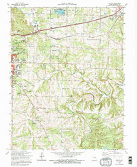
1992 Map of Dillon
USGS Topo · Published 1995About this map
St Louis-San Francisco RR tracks cut a diagonal path across this Phelps County landscape, connecting the regional centers of Rolla and St James. The terrain is defined by the winding course of the Dry Fork and its tributaries, such as Green Acre Branch and Little Dry Fork, which carve through the prominent Schuman Ridge. This 1990s revision reveals a mix of established rural life and specialized development, including the USGS Center and multiple municipal facilities. Genealogical interest is high given the numerous family and community burial grounds scattered throughout the area, including Wishon Cem, Burton Cem, and Elliot Cem. From the waters of Little Prairie Lake to the small settlement at Dillon, the map captures a period of steady growth as residential trailer parks and churches like Bellview Ch appear alongside traditional limestone quarries.
Find a feature on this map
46 named features on this map. Tap any name to fly to it.
Don’t see what you’re looking for? This feature index may not catch every label — zoom into the map to look around manually.
Map Details
Editions of this 1992 Dillon Map
This is the sole edition of this map. No revisions or reprints were ever made.
Other maps of this area

1912 · Rolla
USGS Topo · 1:62,500

1928 · Meramec Spring
USGS Topo · 1:62,500

1934 · Redbird
USGS Topo · 1:62,500

1937 · Vienna
USGS Topo · 1:62,500

1938 · Redbird
USGS Topo · 1:62,500

1938 · Vienna
USGS Topo · 1:48,000

1949 · Saint Louis
USGS Topo · 1:250,000

1949 · Vienna
USGS Topo · 1:62,500

1949 · Rolla
USGS Topo · 1:250,000

1949 · Meramec Spring
USGS Topo · 1:62,500