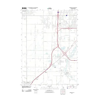
2011 Map of Dimondale
USGS Topo · Published 2011About this map
The Grand River meanders through the landscape south of Lansing, anchoring the riverside village of Dimondale. This 2011 survey captures a suburbanizing region where older agricultural crossroads like West Windsor and Delta Center coexist with modern transportation corridors. The map provides significant genealogical value, documenting numerous burial sites across the township including Pioneer Cemetery, Delta Center Cemetery, and the Pray Cemetery to the south. Local commerce and civic life are centered around the Dimondale Post Office and the Potterville Post Office in the southwest corner. Tributaries like Miller Creek, Carrier Creek, and Silver Creek define the drainage patterns of the area, while the Whaley Drain reflects the historical engineering required to manage the low-lying terrain for development and farming.
Find a feature on this map
89 named features on this map. Tap any name to fly to it.
Don’t see what you’re looking for? This feature index may not catch every label — zoom into the map to look around manually.
Map Details
Editions of this 2011 Dimondale Map
This is the sole edition of this map. No revisions or reprints were ever made.
Other maps of this area

1910 · Lansing
USGS Topo · 1:62,500

1912 · Lansing
USGS Topo · 1:62,500

1927 · De Witt
USGS Topo · 1:62,500

1945 · Portland
USGS Topo · 1:62,500

1949 · Charlotte
USGS Topo · 1:62,500

1958 · Grand Rapids
USGS Topo · 1:250,000

1961 · Grand Rapids
USGS Topo · 1:250,000

1962 · Grand Rapids
USGS Topo · 1:250,000
1965 · Lansing South
USGS Topo · 1:24,000
1965 · Wacousta
USGS Topo · 1:24,000