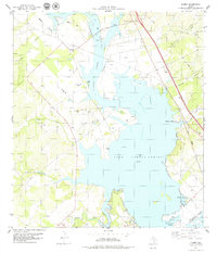
1979 Map of Dinero
USGS Topo · Published 1979About this map
Lake Corpus Christi dominates this 1970s landscape, its waters reaching into the many hollows and creek beds of Live Oak County. Along the western shore, the Nueces River feeds the reservoir near the settlement of Dinero, while the Missouri Pacific railroad corridor runs roughly parallel to the eastern bank. The area shows a mix of recreation and resource extraction, with many Oil Wells and Gravel Pits scattered across the terrain.
Find a feature on this map
29 named features on this map. Tap any name to fly to it.
Don’t see what you’re looking for? This feature index may not catch every label — zoom into the map to look around manually.
Map Details
Editions of this 1979 Dinero Map
This is the sole edition of this map. No revisions or reprints were ever made.
Other maps of this area

1920 · Mikeska
USGS Topo · 1:125,000

1925 · Oakville No. 4
USGS Topo · 1:48,000

1925 · Mathis No. 2
USGS Topo · 1:48,000

1925 · Mathis No. 3
USGS Topo · 1:48,000

1927 · Mathis
USGS Topo · 1:62,500

1927 · Oakville
USGS Topo · 1:62,500

1953 · Crystal City
USGS Topo · 1:250,000

1953 · Beeville
USGS Topo · 1:250,000

1954 · Fleming
USGS Topo · 1:62,500

1954 · Mathis
USGS Topo · 1:62,500