
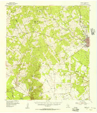
1954 Map of Fleming
USGS Topo · Published 1956About this map
Industrial and agricultural life in central Bee County is defined by the proliferation of petroleum infrastructure alongside traditional ranching. The northern half of the landscape is dominated by the Fleming Oil Field and Holzmark Oil Field, where a dense network of windmills and storage tanks indicates the mid-century peak of local production. This energy economy extends southward into the Rock Hill Oil Field and Silva Oil Field, connected by multiple pipelines that cut across the terrain.
Find a feature on this map
40 named features on this map. Tap any name to fly to it.
Don’t see what you’re looking for? This feature index may not catch every label — zoom into the map to look around manually.
Map Details
Editions of this 1954 Fleming Map
2 editions found
Other maps of this area

1920 · Mikeska
USGS Topo · 1:125,000

1925 · Oakville No. 4
USGS Topo · 1:48,000

1925 · Mathis No. 2
USGS Topo · 1:48,000

1927 · Mathis
USGS Topo · 1:62,500

1927 · Oakville
USGS Topo · 1:62,500

1936 · Pettus
USGS Topo · 1:62,500

1953 · Crystal City
USGS Topo · 1:250,000

1953 · Beeville
USGS Topo · 1:250,000

1954 · Skidmore
USGS Topo · 1:62,500

1954 · Mathis
USGS Topo · 1:62,500