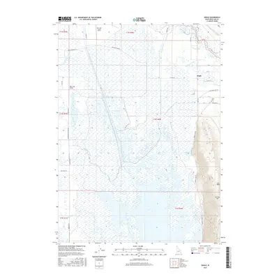
2017 Map of Dingle
USGS Topo · Published 2017About this map
Dingle Swamp dominates the center of this landscape, a vast wetland system within the broader Bear Lake Valley. The intricate water management of the region is evident through an extensive network of man-made waterways, including the Montpelier Preston Canal, Black Otter Canal, and Peg Leg Ditch, which redirect flow across the lowlands. The settlement of Dingle sits at the northeastern edge of these wetlands, serving as a gateway to the steeper elevations of Lake Ridge and Merkley Mtn to the southeast. Local infrastructure is anchored by the Bear Lake County Airport in the north and the nearby Dingle Cem. The hydraulic complexity of the area is further illustrated by the Bear-Lake Outlet and Ream Crockett Canal, reflecting a landscape defined by its historical and ongoing reliance on diverted water for agriculture and valley life.
Find a feature on this map
43 named features on this map. Tap any name to fly to it.
Don’t see what you’re looking for? This feature index may not catch every label — zoom into the map to look around manually.
Map Details
Editions of this 2017 Dingle Map
This is the sole edition of this map. No revisions or reprints were ever made.
Other maps of this area

1909 · Montpelier
USGS Topo · 1:125,000

1911 · Montpelier
USGS Topo · 1:125,000

1955 · Preston
USGS Topo · 1:250,000

1958 · Preston
USGS Topo · 1:250,000

1962 · Preston
USGS Topo · 1:250,000

1967 · Montpelier
USGS Topo · 1:24,000

1967 · Paris
USGS Topo · 1:24,000

1967 · Ovid
USGS Topo · 1:24,000

1967 · Dingle
USGS Topo · 1:24,000
1969 · St Charles
USGS Topo · 1:24,000