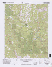
1993 Map of Dinkey Creek
USGS Topo · Published 2002About this map
Sierra National Forest lands dominate this 1993 study, where high-elevation meadows and forestry infrastructure define the landscape. The map centers on the Dinkey Creek corridor, a critical hub for seasonal mountain activity as evidenced by the concentration of facilities like Camp Fresno, Byles Jamison Camp, and the Dinkey Creek Work Center. These sites, along with the Glen Meadow Work Center and Blue Canyon Work Center, reflect a highly managed timber and recreation environment.
Find a feature on this map
32 named features on this map. Tap any name to fly to it.
Don’t see what you’re looking for? This feature index may not catch every label — zoom into the map to look around manually.
Map Details
Editions of this 1993 Dinkey Creek Map
This is the sole edition of this map. No revisions or reprints were ever made.
Other maps of this area

1904 · Kaiser
USGS Topo · 1:125,000

1922 · Trimmer
USGS Topo · 1:96,000

1924 · Dinuba
USGS Topo · 1:125,000

1942 · Watts Valley
USGS Topo · 1:62,500

1944 · Watts Valley
USGS Topo · 1:62,500

1947 · Mariposa
USGS Topo · 1:250,000

1948 · Fresno
USGS Topo · 1:250,000

1948 · Mariposa
USGS Topo · 1:250,000

1952 · Patterson Mountain
USGS Topo · 1:62,500

1953 · Huntington Lake
USGS Topo · 1:62,500