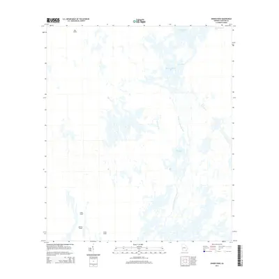
2014 Map of Dinner Pond
USGS Topo · Published 2014About this map
The Middle Fork Suwannee River carves a complex aquatic corridor through Charlton County, defining a landscape where land and water are constantly intertwined. In this 2014 survey, the geography is dominated by expansive wetlands and isolated rises such as Dog Island and Long Island, which provide the only stable ground in a territory defined by shifting hydrology. The drainage pattern is particularly evident through Bird Wing Run, which feeds into a network of larger bodies like Maul Hammock Lake and Big Water Lake. This area represents a preserved wilderness state, where the absence of roads or permanent settlements highlights the natural flow of the Suwannee's headwaters. The map serves as a vital record for understanding the intricate drainage of Dinner Pond and the surrounding hammocks, offering a clear view of the islands—including Minnies Island and Camp Island—that have served as landmarks for generations navigating these southern Georgia wetlands.
Find a feature on this map
9 named features on this map. Tap any name to fly to it.
Don’t see what you’re looking for? This feature index may not catch every label — zoom into the map to look around manually.
Map Details
Editions of this 2014 Dinner Pond Map
This is the sole edition of this map. No revisions or reprints were ever made.
Other maps of this area

1918 · Folkston
USGS Topo · 1:62,500

1953 · Waycross
USGS Topo · 1:250,000

1954 · Valdosta
USGS Topo · 1:250,000

1958 · Valdosta
USGS Topo · 1:250,000

1958 · Waycross
USGS Topo · 1:250,000

1959 · Valdosta
USGS Topo · 1:250,000

1965 · Double Lakes
USGS Topo · 1:24,000

1965 · Chase Prairie
USGS Topo · 1:24,000

1965 · Dinner Pond
USGS Topo · 1:24,000
1966 · Billys Island
USGS Topo · 1:24,000