
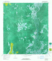
1965 Map of Dinner Pond
USGS Topo · Published 1967About this map
Okefenokee National Wildlife Refuge dominates this mid-1960s phototopographic study, revealing the intricate water and land patterns of the Georgia wetlands. The map shows the Suwannee River winding through a complex of open water and dense vegetation, including Big Water Lake and the eponymous Dinner Pond. A notable industrial artifact is the Dismantled Logging Tram, which cuts a straight line across the northwest corner of the swamp, marking the site of former timber extraction efforts in a landscape now designated for conservation.
Find a feature on this map
17 named features on this map. Tap any name to fly to it.
Don’t see what you’re looking for? This feature index may not catch every label — zoom into the map to look around manually.
Map Details
Editions of this 1965 Dinner Pond Map
2 editions found
Other maps of this area

1918 · Folkston
USGS Topo · 1:62,500

1953 · Waycross
USGS Topo · 1:250,000

1954 · Valdosta
USGS Topo · 1:250,000

1958 · Valdosta
USGS Topo · 1:250,000

1958 · Waycross
USGS Topo · 1:250,000

1959 · Valdosta
USGS Topo · 1:250,000

1965 · Double Lakes
USGS Topo · 1:24,000

1965 · Chase Prairie
USGS Topo · 1:24,000
1966 · Billys Island
USGS Topo · 1:24,000

1966 · The Pocket
USGS Topo · 1:24,000