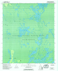
1994 Map of Dinner Pond
USGS Topo · Published 1994About this map
Okefenokee National Wildlife Refuge and Wilderness dominates this mid-1990s survey, revealing a landscape defined by an intricate network of wetlands, islands, and open prairies. This portion of the Okefenokee Swamp is largely trackless, save for the presence of an Old Railroad Grade cutting across the northwestern section, a physical remnant of earlier industrial efforts to navigate this complex environment. The hydrology of the region is anchored by the Suwannee River and major open water features such as Dinner Pond and Big Water Lake. Landforms emerge from the surrounding marsh as distinct islands, including Long Island, Minnies Island, and Dog Island. Broad, open expanses labeled as Sapling Prairie and Island Prairie illustrate the diverse vegetation patterns that characterize this protected ecosystem.
Find a feature on this map
13 named features on this map. Tap any name to fly to it.
Don’t see what you’re looking for? This feature index may not catch every label — zoom into the map to look around manually.
Map Details
Editions of this 1994 Dinner Pond Map
This is the sole edition of this map. No revisions or reprints were ever made.
Other maps of this area

1918 · Folkston
USGS Topo · 1:62,500

1953 · Waycross
USGS Topo · 1:250,000

1954 · Valdosta
USGS Topo · 1:250,000

1958 · Valdosta
USGS Topo · 1:250,000

1958 · Waycross
USGS Topo · 1:250,000

1959 · Valdosta
USGS Topo · 1:250,000

1965 · Double Lakes
USGS Topo · 1:24,000

1965 · Chase Prairie
USGS Topo · 1:24,000

1965 · Dinner Pond
USGS Topo · 1:24,000
1966 · Billys Island
USGS Topo · 1:24,000