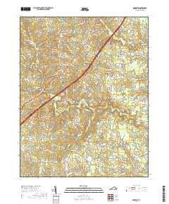
2019 Map of Dinwiddie
USGS Topo · Published 2019About this map
The Dinwiddie County Courthouse stands as the civic anchor of this Virginia landscape, where modern transportation corridors intersect with deep-rooted community foundations. Small settlements like Dinwiddie and Hamilton are surrounded by a high density of historic family and church burial grounds, including the Olive Branch Cem and Hawkins Memorial Cem. These sites, along with Mount Level Baptist Church, provide essential touchpoints for genealogical research in a region where the land has long been defined by its watercourses.
Find a feature on this map
67 named features on this map. Tap any name to fly to it.
Don’t see what you’re looking for? This feature index may not catch every label — zoom into the map to look around manually.
Map Details
Editions of this 2019 Dinwiddie Map
This is the sole edition of this map. No revisions or reprints were ever made.
Other maps of this area

1894 · Petersburg
USGS Topo · 1:62,500

1897 · Amelia
USGS Topo · 1:125,000

1919 · Jarratt
USGS Topo · 1:62,500

1919 · Mc Kenney
USGS Topo · 1:48,000

1921 · Mc Kenney
USGS Topo · 1:62,500

1943 · Mc Kenney
USGS Topo · 1:62,500

1943 · De Witt
USGS Topo · 1:24,000

1943 · Dinwiddie
USGS Topo · 1:24,000

1943 · Church Road
USGS Topo · 1:24,000

1943 · Sutherland
USGS Topo · 1:24,000