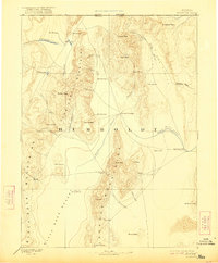
1893 Map of Disaster
USGS Topo · Published 1922About this map
Black Rock Desert and the high peaks of the Pine Forest Mountains define this remote expanse of northwestern Nevada during the late nineteenth century. Surveyed in 1882, the map documents a landscape where water is the primary driver of travel and settlement, centered on the intermittent Quinn River and its eventual disappearance at the Sink of Quinn River. The scarcity of water is punctuated by numerous Hot Springs and established watering points like Mason's Crossing and Sod House Point, which served as vital stops for those traversing the high desert. To the north, the Oregon Nevada Boundary Line runs past Disaster Peak and Trident Peak. This 1893 edition provides a look at the early topography of the Jackson Mountains, identifying named landmarks such as King Lear and Parrot Peak before modern developments altered the region's character.
Find a feature on this map
48 named features on this map. Tap any name to fly to it.
Don’t see what you’re looking for? This feature index may not catch every label — zoom into the map to look around manually.
Map Details
Editions of this 1893 Disaster Map
5 editions found
Other maps of this area

1882 · Paradise
USGS Topo · 1:250,000

1886 · Disaster
USGS Topo · 1:250,000

1886 · Granite Range
USGS Topo · 1:250,000

1889 · Long Valley
USGS Topo · 1:250,000

1893 · Paradise
USGS Topo · 1:250,000

1893 · Disaster
USGS Topo · 1:250,000

1894 · Granite Range
USGS Topo · 1:250,000

1931 · Lovelock
USGS Topo · 1:250,000

1932 · Sonoma Range
USGS Topo · 1:250,000

1935 · Lovelock
USGS Topo · 1:250,000