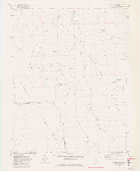
1979 Map of Disaster Peak
USGS Topo · Published 1980About this map
Pacific Crest National Scenic Trail traverses the high-altitude boundary of the Toiyabe National Forest and Stanislaus National Forest, providing a detailed view of this high Sierra Nevada landscape during the late 1970s. The map captures the divide between Alpine and Tuolumne counties, where the headwaters of the East Fork Carson River and the Clark Fork originate among massive geological formations. Notable landmarks such as The Iceberg and Disaster Peak dominate the topography, while numerous small water bodies like Poison Lake and Whitecliff Lake dot the basins. The survey records a network of established paths including the Paradise Valley Trail, showing the primitive infrastructure used for forest management and wilderness access before modern digital mapping, including the specific locations of Carson Falls and various seasonal Springs.
Find a feature on this map
35 named features on this map. Tap any name to fly to it.
Don’t see what you’re looking for? This feature index may not catch every label — zoom into the map to look around manually.
Map Details
Editions of this 1979 Disaster Peak Map
4 editions found
Other maps of this area

1889 · Markleeville
USGS Topo · 1:125,000

1891 · Markleeville
USGS Topo · 1:125,000

1893 · Markleeville
USGS Topo · 1:125,000

1896 · Dardanelles
USGS Topo · 1:125,000

1898 · Dardanelles
USGS Topo · 1:125,000

1948 · Walker Lake
USGS Topo · 1:250,000

1954 · Pickel Meadow
USGS Topo · 1:24,000

1954 · Lost Cannon Peak
USGS Topo · 1:24,000

1956 · Topaz Lake
USGS Topo · 1:62,500

1956 · Markleeville
USGS Topo · 1:62,500