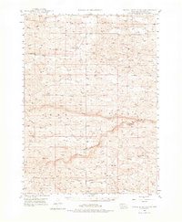
1947 Map of Dismal River Ranch
USGS Topo · Published 1976About this map
Dismal River Ranch serves as a central landmark in this remote corner of Hooker County, where the topography is defined by the branching waterways of the Dismal River. This 1947 field-checked survey reveals a landscape of massive dunes and interdunal valleys, labeled here as Mullen, Abby, and Valley. The pattern of human activity is dictated by water and education, with one-room schoolhouses like Maire Sch, Vandeusen Sch, and Haney Sch serving the ranching families scattered across the Sandhills. Dozens of isolated Windmill sites are marked throughout the terrain, indicating the critical importance of groundwater for cattle in a region where surface water is limited to the North Fork Dismal River, the South Fork Dismal River, and Spring Creek.
Find a feature on this map
15 named features on this map. Tap any name to fly to it.
Don’t see what you’re looking for? This feature index may not catch every label — zoom into the map to look around manually.
Map Details
Editions of this 1947 Dismal River Ranch Map
2 editions found
Other maps of this area

1947 · Dismal River Ranch
USGS Topo · 1:62,500

1948 · Seneca
USGS Topo · 1:62,500

1948 · Carr Lake
USGS Topo · 1:62,500

1948 · Mullen
USGS Topo · 1:62,500

1949 · Dismal River Ranch
USGS Topo · 1:62,500

1949 · Flats
USGS Topo · 1:62,500

1949 · Wright Valley
USGS Topo · 1:62,500

1950 · Flats
USGS Topo · 1:62,500

1950 · Carr Lake
USGS Topo · 1:62,500

1950 · Hire
USGS Topo · 1:62,500