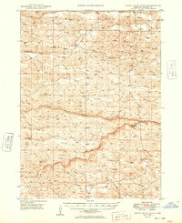
1949 Map of Dismal River Ranch
USGS Topo · Published 1949About this map
Abby Valley and the surrounding Sandhills of Hooker County are defined by a high concentration of water-drawing infrastructure in the late 1940s. The landscape is dotted with numerous windmills, essential for the cattle operations that center on the Dismal River Ranch. This region, surveyed for the Bureau of Reclamation, shows a settlement pattern of isolated ranching outposts and a surprisingly robust network of rural education. No fewer than six schools, including Vandeusen Sch, Maire Sch, and Hatch Sch, serve the families scattered across the dunes. The hydrology is centered on the confluence where the North Fork and South Fork join to form the Dismal River, alongside the meandering path of Spring Creek. The distribution of these family-named schools and ranches provides a clear look at the mid-century ranching economy in the Nebraska interior.
Find a feature on this map
13 named features on this map. Tap any name to fly to it.
Don’t see what you’re looking for? This feature index may not catch every label — zoom into the map to look around manually.
Map Details
Editions of this 1949 Dismal River Ranch Map
2 editions found
Other maps of this area

1947 · Dismal River Ranch
USGS Topo · 1:62,500

1948 · Seneca
USGS Topo · 1:62,500

1948 · Carr Lake
USGS Topo · 1:62,500

1948 · Mullen
USGS Topo · 1:62,500

1949 · Dismal River Ranch
USGS Topo · 1:62,500

1949 · Flats
USGS Topo · 1:62,500

1949 · Wright Valley
USGS Topo · 1:62,500

1950 · Flats
USGS Topo · 1:62,500

1950 · Carr Lake
USGS Topo · 1:62,500

1950 · Hire
USGS Topo · 1:62,500