
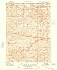
1949 Map of Dismal River Ranch
USGS Topo · Published 1949About this map
The Dismal River Ranch serves as a primary landmark in this ranching-focused landscape of central Nebraska. Recorded shortly after the war, the geography is defined by the convergence of the North Fork and South Fork into the main Dismal River channel. A network of rural education sites, including Maire Sch, Vandeusen Sch, Haney Sch, Hatch Sch, Shimmins Sch, and Center Sch, is distributed across the Sandhills terrain, indicating the locations of established family ranching operations. The prevalence of scattered Windmill labels underscores the vital importance of groundwater management in this semi-arid environment, where these structures provided the necessary water supply for both households and livestock far from the permanent flows of Spring Creek.
Find a feature on this map
20 named features on this map. Tap any name to fly to it.
Don’t see what you’re looking for? This feature index may not catch every label — zoom into the map to look around manually.
Map Details
Editions of this 1949 Dismal River Ranch Map
2 editions found
Other maps of this area

1947 · Dismal River Ranch
USGS Topo · 1:62,500

1948 · Seneca
USGS Topo · 1:62,500

1948 · Carr Lake
USGS Topo · 1:62,500

1948 · Mullen
USGS Topo · 1:62,500

1949 · Flats
USGS Topo · 1:62,500

1949 · Wright Valley
USGS Topo · 1:62,500

1950 · Flats
USGS Topo · 1:62,500

1950 · Carr Lake
USGS Topo · 1:62,500

1950 · Hire
USGS Topo · 1:62,500

1950 · Shimmins Lake
USGS Topo · 1:62,500