
1967 Map of Divide Country
USGS Topo · Published 1970About this map
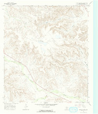
Upper Fourmile Draw and Lower Fourmile Draw cut through this high plateau region of Pecos County, illustrating a landscape defined by intermittent drainage systems and petroleum exploration. During the late 1960s, this area known as Divide Country was characterized by an extensive network of Oil Wells and numerous Drill Holes, marking the industrial footprint on the West Texas terrain. The map captures the complex topography of the Yates area, where seasonal watercourses like South Sixmile Draw and Little Riffle Canyon have carved deep relief into the divide. This survey serves as a precise record of the mid-century oil infrastructure, showing the locations of tanks and towers alongside the natural draws that once dictated movement through this arid territory.
Find a feature on this map
14 named features on this map. Tap any name to fly to it.
Don’t see what you’re looking for? This feature index may not catch every label — zoom into the map to look around manually.
Map Details
Editions of this 1967 Divide Country Map
2 editions found
Other maps of this area

1929 · Sheffield
USGS Topo · 1:125,000

1929 · Independence Draw Quadrangle
USGS Topo · 1:125,000

1954 · Fort Stockton
USGS Topo · 1:250,000

1954 · Sonora
USGS Topo · 1:250,000

1958 · Sonora
USGS Topo · 1:250,000

1958 · Fort Stockton
USGS Topo · 1:250,000

1967 · Twelvemile Camp
USGS Topo · 1:24,000

1967 · Sheffield NW
USGS Topo · 1:24,000

1967 · Deer Canyon
USGS Topo · 1:24,000
1967 · Iraan
USGS Topo · 1:24,000