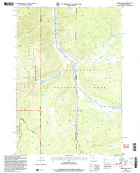
2000 Map of Divide Lake
USGS Topo · Published 2005About this map
The Gallatin River carves a central path through this high-altitude landscape, serving as a corridor between major protected lands at the turn of the millennium. The map documents the intersection of three significant administrative zones: Yellowstone National Park, the Gallatin National Forest, and the Lee Metcalf Wilderness. This convergence highlights a region managed for both preservation and recreation, including the specialized Cabin Creek Wildlife and Recreation Management Area.
Find a feature on this map
24 named features on this map. Tap any name to fly to it.
Don’t see what you’re looking for? This feature index may not catch every label — zoom into the map to look around manually.
Map Details
Editions of this 2000 Divide Lake Map
This is the sole edition of this map. No revisions or reprints were ever made.
Other maps of this area

1885 · Gallatin
USGS Topo · 1:125,000

1885 · Gallatin
USGS Topo · 1:125,000

1888 · Three Forks
USGS Topo · 1:250,000

1891 · Livingston
USGS Topo · 1:250,000

1893 · Livingston
USGS Topo · 1:250,000

1894 · Three Forks
USGS Topo · 1:250,000

1895 · Three Forks
USGS Topo · 1:250,000

1901 · Gallatin
USGS Topo · 1:125,000

1908 · Gallatin
USGS Topo · 1:125,000

1911 · Gallatin
USGS Topo · 1:125,000