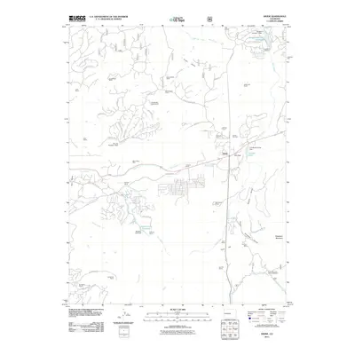
2011 Map of Divide
USGS Topo · Published 2011About this map
The mountain community of Divide serves as the focal point for this survey, situated at the historic summit of Ute Pass. The landscape is defined by a dense network of private ranch holdings and water management infrastructure, including the Burgess Reservoir Number 1 and Coulson Lake. A legacy of high-altitude mining is evident at the Black Cloud Mine near Twin Creek and the Emma L Mine tucked into the drainage of Orchette Gulch. Notable for genealogists and local historians, the Divide Cemetery and the Rocky Mountain Mennonite Camp reflect the social fabric of the area. The terrain transitions from the heights of Raspberry Mountain and Tracy Hill down into several drainages like Rule Creek and Fourmile Creek, showing a pattern of modern residential developments such as Skyway Ranch and Arrowhead Ranch interspersed with traditional guest ranches like the Golden Bell Guest Ranch.
Find a feature on this map
81 named features on this map. Tap any name to fly to it.
Don’t see what you’re looking for? This feature index may not catch every label — zoom into the map to look around manually.
Map Details
Editions of this 2011 Divide Map
This is the sole edition of this map. No revisions or reprints were ever made.
Other maps of this area

1893 · Platte Canyon
USGS Topo · 1:125,000

1894 · Pikes Peak
USGS Topo · 1:125,000

1901 · Pikes Peak
USGS Topo · 1:125,000

1901 · Pikes Peak
USGS Topo · 1:62,500
1951 · Pikes Peak
USGS Topo · 1:24,000

1951 · Cripple Creek North
USGS Topo · 1:24,000

1953 · Denver
USGS Topo · 1:250,000

1954 · Mount Deception
USGS Topo · 1:24,000

1954 · Woodland Park
USGS Topo · 1:24,000

1954 · Signal Butte
USGS Topo · 1:24,000