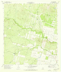
1974 Map of Divot
USGS Topo · Published 1977About this map
The small settlement of Divot serves as the focal point for this rural landscape in Frio County, where the sprawling river bottom of the Leona River dominates the central terrain. This mid-1970s survey reveals a landscape heavily defined by its water management and ranching infrastructure. Numerous named windmills, including the Sally Windmill, Berry Creek Windmill, and Parks Corner Windmill, are scattered across the hills and valleys to provide water for livestock in this arid brush country.
Find a feature on this map
26 named features on this map. Tap any name to fly to it.
Don’t see what you’re looking for? This feature index may not catch every label — zoom into the map to look around manually.
Map Details
Editions of this 1974 Divot Map
This is the sole edition of this map. No revisions or reprints were ever made.
Other maps of this area

1925 · Pearsall 1-b
USGS Topo · 1:48,000

1925 · Pearsall 1-c
USGS Topo · 1:48,000

1927 · Pearsall
USGS Topo · 1:62,500

1942 · Divot
USGS Topo · 1:62,500

1942 · Dilley
USGS Topo · 1:62,500

1953 · Crystal City
USGS Topo · 1:250,000

1955 · Crystal City
USGS Topo · 1:250,000

1956 · Woodward
USGS Topo · 1:62,500

1956 · Divot
USGS Topo · 1:62,500

1961 · Crystal City
USGS Topo · 1:250,000