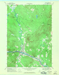
1968 Map of Dixfield
USGS Topo · Published 1971About this map
The Androscoggin River serves as the primary corridor for industry and transit in this late 1960s survey, with the Maine Central railroad tracking the southern riverbank. The village of Dixfield is positioned at the confluence of the Webb River and the Androscoggin, while the neighboring settlements of Peru and West Peru sit across the water. A distinctive pattern of upland ridges such as Harlow Ridge and Staples Ridge define the northern terrain, separated by numerous small waterways like Kittredge Brook and Masterman Brook.
Find a feature on this map
57 named features on this map. Tap any name to fly to it.
Don’t see what you’re looking for? This feature index may not catch every label — zoom into the map to look around manually.
Map Details
Editions of this 1968 Dixfield Map
2 editions found
Other maps of this area

1911 · Bryant Pond
USGS Topo · 1:62,500

1911 · Buckfield
USGS Topo · 1:62,500

1913 · Buckfield
USGS Topo · 1:62,500

1914 · Bryant Pond
USGS Topo · 1:62,500

1926 · Dixfield
USGS Topo · 1:62,500

1927 · Rumford
USGS Topo · 1:48,000

1929 · Dixfield
USGS Topo · 1:62,500

1930 · Rumford
USGS Topo · 1:62,500

1942 · Buckfield
USGS Topo · 1:62,500

1942 · Bryant Pond
USGS Topo · 1:62,500