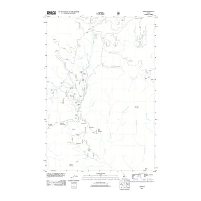
2011 Map of Dixie
USGS Topo · Published 2011About this map
Dixie serves as the focal point for this mountain landscape dominated by a dense network of historic mining claims and alpine waterways. The topography is defined by the steep drainages of Crooked Creek and Boulder Creek, which provided the water essential for early gold operations. Evidence of the region's mineral heritage is everywhere, from the cluster of workings at Midasville to more remote sites like the Swastika Mine and Black Diamond Mine. The map reveals how the local economy relied on specific corridors such as Fourth of July Creek, where numerous small mines like the Slip Easy Mine and Tiawaka Mine are located. High-elevation points like Blowout Mountain and Churchill Mountain overlook a landscape of deep gulches and high meadows, including Little Mallard Meadows, reflecting a rugged Idaho backcountry that remained largely oriented around its primary resource extraction roots well into the 21st century.
Find a feature on this map
58 named features on this map. Tap any name to fly to it.
Don’t see what you’re looking for? This feature index may not catch every label — zoom into the map to look around manually.
Map Details
Editions of this 2011 Dixie Map
This is the sole edition of this map. No revisions or reprints were ever made.
Other maps of this area

1931 · Buffalo Hump
USGS Topo · 1:125,000

1934 · Buffalo Hump
USGS Topo · 1:125,000

1956 · Warren
USGS Topo · 1:62,500

1956 · Elk City
USGS Topo · 1:250,000

1960 · Elk City
USGS Topo · 1:250,000

1977 · Silver Spur Ridge
USGS Topo · 1:24,000

1978 · Moose Butte
USGS Topo · 1:24,000

1978 · Trapper Creek
USGS Topo · 1:24,000
1979 · Orogrande
USGS Topo · 1:24,000

1979 · Dixie
USGS Topo · 1:24,000