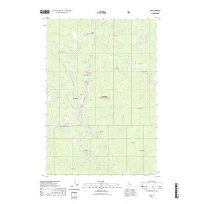
2020 Map of Dixie
USGS Topo · Published 2020About this map
The mountain settlement of Dixie and the neighboring locale of Midasville are the focal points of this 2020 survey of Idaho County. Situated within the Nez Perce National Forest, the region is defined by a dense network of creek drainages and high ridges. Significant elevation changes are marked by Dixie Summit to the north and various peaks such as Burpee Mtn and Sinker Mtn. The landscape is etched with the history of extraction and travel, visible in the naming of Nugget Gulch, Dixie Gulch, and Hundred Dollar Gulch. Water is central to the area's geography, with the S Fork Red River in the north and Crooked Creek winding through the center, feeding into high-elevation clearings like North Star Meadows and Little Mallard Meadows. This map provides a detailed view of the remote road networks, including Nat For Dev Rd 1108 and Airway Dr, that serve these isolated Idaho communities.
Find a feature on this map
49 named features on this map. Tap any name to fly to it.
Don’t see what you’re looking for? This feature index may not catch every label — zoom into the map to look around manually.
Map Details
Editions of this 2020 Dixie Map
This is the sole edition of this map. No revisions or reprints were ever made.
Other maps of this area

1931 · Buffalo Hump
USGS Topo · 1:125,000

1934 · Buffalo Hump
USGS Topo · 1:125,000

1956 · Warren
USGS Topo · 1:62,500

1956 · Elk City
USGS Topo · 1:250,000

1960 · Elk City
USGS Topo · 1:250,000

1977 · Silver Spur Ridge
USGS Topo · 1:24,000

1978 · Moose Butte
USGS Topo · 1:24,000

1978 · Trapper Creek
USGS Topo · 1:24,000
1979 · Orogrande
USGS Topo · 1:24,000

1979 · Dixie
USGS Topo · 1:24,000