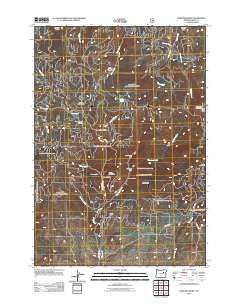
2011 Map of Dixie Meadows
USGS Topo · Published 2011About this map
Dixie Meadows Mine and several other mining operations define the rugged industrial character of this Grant County landscape. Located south of Ragged Rocks, these sites highlight a legacy of mineral extraction concentrated around Standard Creek and Dixie Creek. The presence of the Copperopolis Mine, Smuggler Mine, and Keystone Mine within a relatively small area suggests a dense network of claims and workings tied to the region's geologic potential.
Find a feature on this map
36 named features on this map. Tap any name to fly to it.
Don’t see what you’re looking for? This feature index may not catch every label — zoom into the map to look around manually.
Map Details
Editions of this 2011 Dixie Meadows Map
This is the sole edition of this map. No revisions or reprints were ever made.
Other maps of this area

1940 · John Day
USGS Topo · 1:62,500

1943 · John Day
USGS Topo · 1:62,500

1949 · Susanville
USGS Topo · 1:62,500

1951 · Susanville
USGS Topo · 1:62,500

1951 · Bates
USGS Topo · 1:62,500

1955 · Canyon City
USGS Topo · 1:250,000

1959 · Canyon City
USGS Topo · 1:250,000

1959 · Prairie City
USGS Topo · 1:62,500
1972 · Castle Creek
USGS Topo · 1:24,000

1978 · John Day
USGS Topo · 1:100,000