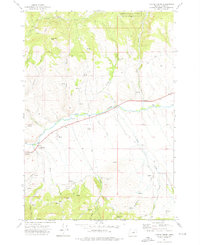
1972 Map of Castle Creek
USGS Topo · Published 1976About this map
The John Day River flows through this 1972 survey of Grant County, Oregon, defining the central drainage system of a landscape marked by ranching and resource extraction. Within the northern boundary, the Malheur National Forest encompasses steep terrain leading to Butch Foster Saddle. The southern half of the map reveals the area's prospecting history, with several identified Mine locations and the Prairie Diggings situated near Red Hill. A dense network of seasonal and perennial water sources like Johnson Springs and Dead Horse Spring supported local movement along numerous unnamed tracks and established jeep trails. The mapping shows a transition from high-elevation forest to the river valley, where tributaries such as Castle Creek, Pine Creek, and Indian Creek converge with the main river channel.
Find a feature on this map
29 named features on this map. Tap any name to fly to it.
Don’t see what you’re looking for? This feature index may not catch every label — zoom into the map to look around manually.
Map Details
Editions of this 1972 Castle Creek Map
3 editions found
Other maps of this area

1940 · John Day
USGS Topo · 1:62,500

1943 · John Day
USGS Topo · 1:62,500

1949 · Susanville
USGS Topo · 1:62,500

1951 · Susanville
USGS Topo · 1:62,500

1951 · Bates
USGS Topo · 1:62,500

1955 · Canyon City
USGS Topo · 1:250,000

1959 · Canyon City
USGS Topo · 1:250,000

1959 · Prairie City
USGS Topo · 1:62,500

1972 · John Day
USGS Topo · 1:24,000

1972 · Canyon Mtn
USGS Topo · 1:24,000