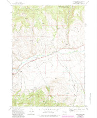
1972 Map of Castle Creek
USGS Topo · Published 1984About this map
The John Day River flows through this rugged portion of Grant County, Oregon, defining the landscape's primary drainage. This 1970s survey shows the intersection of natural resources and high-desert terrain within the Malheur National Forest. Historical mining activity is evidenced by the Prairie Diggings in the southwest and a scattered Mine, reflecting the region's extraction heritage. Small-scale landmarks like Butch Foster Saddle and Red Hill provide specific points of reference for local history researchers.
Find a feature on this map
25 named features on this map. Tap any name to fly to it.
Don’t see what you’re looking for? This feature index may not catch every label — zoom into the map to look around manually.
Map Details
Editions of this 1972 Castle Creek Map
3 editions found
Other maps of this area

1940 · John Day
USGS Topo · 1:62,500

1943 · John Day
USGS Topo · 1:62,500

1949 · Susanville
USGS Topo · 1:62,500

1951 · Susanville
USGS Topo · 1:62,500

1951 · Bates
USGS Topo · 1:62,500

1955 · Canyon City
USGS Topo · 1:250,000

1959 · Canyon City
USGS Topo · 1:250,000

1959 · Prairie City
USGS Topo · 1:62,500

1972 · John Day
USGS Topo · 1:24,000

1972 · Canyon Mtn
USGS Topo · 1:24,000