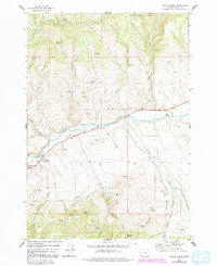
1972 Map of Castle Creek
USGS Topo · Published 1991About this map
Malheur National Forest dominates the high-elevation terrain of eastern Oregon, where the headwaters of the John Day River cut through the landscape. This 1970s record shows the prominence of mineral extraction and livestock management in the region, centered around features like the Prairie Diggings and a remote Mine located south of Red Hill. The map's detail provides a look at the historical water distribution system necessary for this environment, marking numerous specific locations such as Cottonwood Spring, Jones Spring, and Johnson Springs. Significant drainage systems including Indian Creek, Castle Creek, and Deep Creek are meticulously charted, alongside landmarks like Butch Foster Saddle and a documented Corral. This survey reflects the intersection of federal forest management and local resource use at the time.
Find a feature on this map
28 named features on this map. Tap any name to fly to it.
Don’t see what you’re looking for? This feature index may not catch every label — zoom into the map to look around manually.
Map Details
Editions of this 1972 Castle Creek Map
3 editions found
Other maps of this area

1940 · John Day
USGS Topo · 1:62,500

1943 · John Day
USGS Topo · 1:62,500

1949 · Susanville
USGS Topo · 1:62,500

1951 · Susanville
USGS Topo · 1:62,500

1951 · Bates
USGS Topo · 1:62,500

1955 · Canyon City
USGS Topo · 1:250,000

1959 · Canyon City
USGS Topo · 1:250,000

1959 · Prairie City
USGS Topo · 1:62,500

1972 · John Day
USGS Topo · 1:24,000

1972 · Canyon Mtn
USGS Topo · 1:24,000