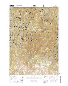
2014 Map of Dixie Meadows
USGS Topo · Published 2014About this map
Dixie Meadows sits at the heart of this high-elevation landscape within the Malhuer National Forest, where the terrain is defined by a dense network of gulches and creeks. The hydrology of the area is particularly complex, with Wickup Cr, Standard Cr, and Dads Cr carving deep into the mountain slopes. Evidence of land use and local history appears in names like Slaughterhouse Gulch and Honeymoon Canyon, suggesting a legacy of ranching and early backcountry exploration. High points such as Dixie Butte and the prominent Ragged Rocks oversee a region accessed by a web of forest service routes, including the Dixie Creek Rd and the Natl Forest Develop Road 791 Rd. The map also captures the transition from the protected forest land toward the John Day Hwy corridor near Ricco Ranch Ln.
Find a feature on this map
36 named features on this map. Tap any name to fly to it.
Don’t see what you’re looking for? This feature index may not catch every label — zoom into the map to look around manually.
Map Details
Editions of this 2014 Dixie Meadows Map
This is the sole edition of this map. No revisions or reprints were ever made.
Other maps of this area

1940 · John Day
USGS Topo · 1:62,500

1943 · John Day
USGS Topo · 1:62,500

1949 · Susanville
USGS Topo · 1:62,500

1951 · Susanville
USGS Topo · 1:62,500

1951 · Bates
USGS Topo · 1:62,500

1955 · Canyon City
USGS Topo · 1:250,000

1959 · Canyon City
USGS Topo · 1:250,000

1959 · Prairie City
USGS Topo · 1:62,500
1972 · Castle Creek
USGS Topo · 1:24,000

1978 · John Day
USGS Topo · 1:100,000