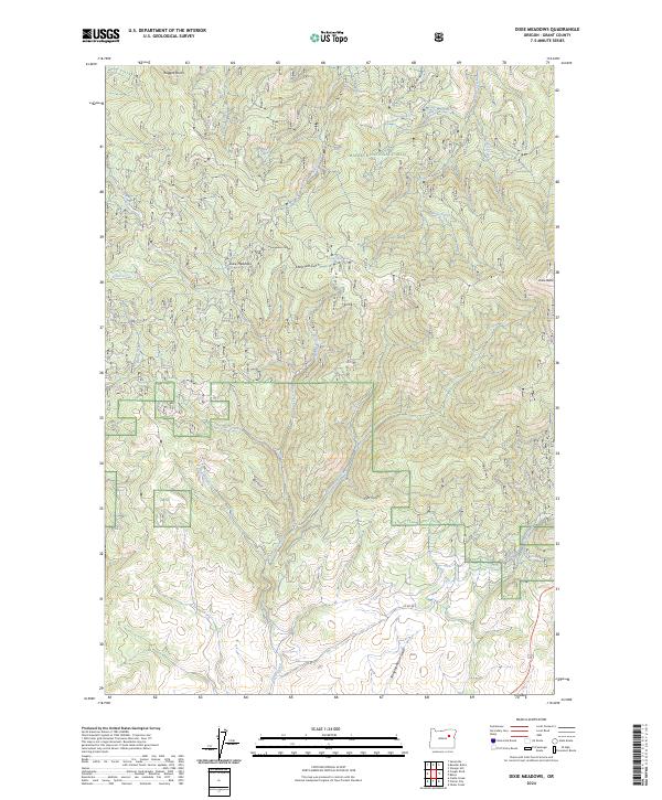
2024 Map of Dixie Meadows
USGS Topo · Published 2024About this map
Malheur National Forest dominates this section of the Blue Mountains, where the high-elevation landscape is defined by a dense network of drainages and named ridges. At Dixie Meadows, the terrain levels out briefly among the headwaters of Dixie Creek, a site of historical significance in a region shaped by timber and early grazing. The topography is marked by several notable geological features, including the prominent peak of Dixie Butte to the east and the sharp formations of Ragged Rocks in the north. This 2024 survey details the intricate network of forest service roads and local routes, such as Co RD 59, that navigate through deep-cut valleys like Honeymoon Canyon and Long Tom Gulch. The map provides an essential record of water sources and landmarks like Wickup Spring, reflecting the area's continued use for resource management and backcountry recreation.
Find a feature on this map
31 named features on this map. Tap any name to fly to it.
Don’t see what you’re looking for? This feature index may not catch every label — zoom into the map to look around manually.
Map Details
Editions of this 2024 Dixie Meadows Map
This is the sole edition of this map. No revisions or reprints were ever made.
Other maps of this area

1940 · John Day
USGS Topo · 1:62,500

1943 · John Day
USGS Topo · 1:62,500

1949 · Susanville
USGS Topo · 1:62,500

1951 · Susanville
USGS Topo · 1:62,500

1951 · Bates
USGS Topo · 1:62,500

1955 · Canyon City
USGS Topo · 1:250,000

1959 · Canyon City
USGS Topo · 1:250,000

1959 · Prairie City
USGS Topo · 1:62,500
1972 · Castle Creek
USGS Topo · 1:24,000

1978 · John Day
USGS Topo · 1:100,000