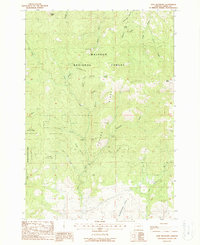
1988 Map of Dixie Meadows
USGS Topo · Published 1988About this map
Malheur National Forest dominates this mountain landscape in Grant County, where the high-altitude terrain is defined by a concentration of historic mining claims. The drainage basins of Dixie Creek and Wickup Creek are dotted with numerous workings, including the Dixie Meadows Mine, Keystone Mine, and the Standard Mine. These sites indicate a legacy of hard-rock extraction along the steep flanks of Cougar Ridge and near the prominent Dixie Butte. The map details a complex network of gulches and canyons, such as Ella Gulch and Slaughterhouse Gulch, that provided the topographical framework for resource development in the late twentieth century. This survey records the remote logging and mining access routes that crisscross the forest, providing a clear picture of the industrial footprint within the protected wilderness before more recent environmental changes.
Find a feature on this map
32 named features on this map. Tap any name to fly to it.
Don’t see what you’re looking for? This feature index may not catch every label — zoom into the map to look around manually.
Map Details
Editions of this 1988 Dixie Meadows Map
This is the sole edition of this map. No revisions or reprints were ever made.
Other maps of this area

1940 · John Day
USGS Topo · 1:62,500

1943 · John Day
USGS Topo · 1:62,500

1949 · Susanville
USGS Topo · 1:62,500

1951 · Susanville
USGS Topo · 1:62,500

1951 · Bates
USGS Topo · 1:62,500

1955 · Canyon City
USGS Topo · 1:250,000

1959 · Canyon City
USGS Topo · 1:250,000

1959 · Prairie City
USGS Topo · 1:62,500
1972 · Castle Creek
USGS Topo · 1:24,000

1978 · John Day
USGS Topo · 1:100,000