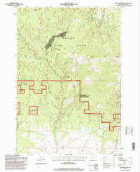
1996 Map of Dixie Meadows
USGS Topo · Published 1998About this map
Dixie Meadows Mine and a dense cluster of hard-rock prospects define the industrial character of this portion of the Malheur National Forest during the late twentieth century. Located within the Blue Mountains, the landscape is heavily dissected by drainages such as Dixie Creek and Lick Creek, which historically served as corridors for mineral exploration. The presence of named sites like the Copperopolis Mine, Smuggler Mine, and Keystone Mine indicates a legacy of prospecting concentrated along the high ridges of Cougar and Ridge. Beyond the mines, the terrain is marked by remote landmarks like Ragged Rock and the Dixie Lookout Butte, which provided vantage points over the deep canyons of Honeymoon Canyon and Buck Gulch. This survey captures the region as it transitioned into a modern recreational forest while retaining the physical scars and named legacy of its mining era.
Find a feature on this map
46 named features on this map. Tap any name to fly to it.
Don’t see what you’re looking for? This feature index may not catch every label — zoom into the map to look around manually.
Map Details
Editions of this 1996 Dixie Meadows Map
This is the sole edition of this map. No revisions or reprints were ever made.
Other maps of this area

1940 · John Day
USGS Topo · 1:62,500

1943 · John Day
USGS Topo · 1:62,500

1949 · Susanville
USGS Topo · 1:62,500

1951 · Susanville
USGS Topo · 1:62,500

1951 · Bates
USGS Topo · 1:62,500

1955 · Canyon City
USGS Topo · 1:250,000

1959 · Canyon City
USGS Topo · 1:250,000

1959 · Prairie City
USGS Topo · 1:62,500
1972 · Castle Creek
USGS Topo · 1:24,000

1978 · John Day
USGS Topo · 1:100,000